
The Flysch route of the northern coast in Spain
Discover the Flysch Route in Spain, on the coast of the Basque Country
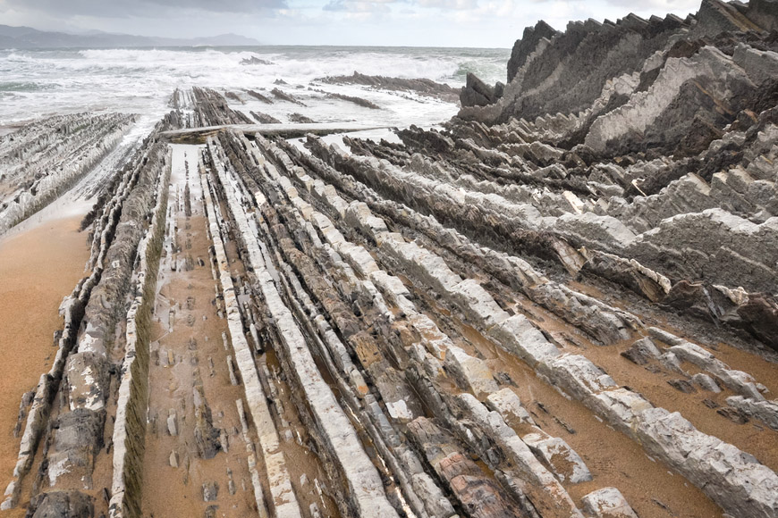
On the cliffs of the west coast of Guipuzcoa we can find a marvel of nature more than 13 kilometers long. Among Deba, Mutriku and Zumaia you’ll see this hidden particular treasure of the flysch, also known as the Geopark of the Basque Coast.
What is a flysch?
The flysch in Spain are geological phenomena caused by the erosion of the sea during millions of years in the limestone and marl rocks of the region. Thanks to them, you can know the history of the Earth for more than 60 million years. For this you only need to know how to read these particular books.
Thanks to the value of this rock formations, the commitment to the conservation of culture and the value of the natural environment, the Basque coast is the first of all the Bay of Biscay to achieve the distinction of Geopark.
To enjoy one of the most beautiful routes of the Basque Country you can choose between doing it by boat or on foot.If you really want to enjoy the best scenery we recommend doing it on foot and spend some of the best sports holidays in the north of Spain.
The best routes to see Flysch in Spain
Set off from Algorri
The route can be started in Zumaia, in the path of Algorri that starts at the hermitage of San Telmo. You have 15 kilometers of trails ahead of you, beaches and cliffs that will not leave you indifferent. From the hermitage you must take the path that is just behind it and go down some stairs to access the beach. This section is one of the most spectacular of the entire route. As soon as you get to the beach you can see the first flysch formations that date back to the Paleocene.
The most spectacular views of the flysch in Elorriaga
After walking the 4 kilometers of beach, you climb again to take the path. In Elorriaga you will find one of the most spectacular views of the route with cliffs of one hundred meters in height, which offer unparalleled views.
Sakoneta
If you continue parallel to the coast towards the northwest, you will eventually reach the cliffs and the creeks of Sakoneta, where if the tide is low you can enjoy the flysch again. This section is the last one that will be walked in the beach. From this place the views will be from the cliffs or the forests of Deba.
Talaia, the hardest of this route to the flysch
This stage of the trail of Talaia, in Itxaspe, is one of the most interesting, but also the hardest of the entire route. Continuing the path, you reach the hermitage of Santa Catalina at the beach of Deba.
Lapari: the black flysch
The black flysch is one of the oldest rocks in the whole route. This section of the route is taken from the seafront of Deba and continues next to the beaches.
This trail is considered the end of the Flysch Route.
Reccommendations
Before starting, we recommend you to check the weather and the tide chart. To be able to enjoy the entire route with all its splendor, you must do it when it’s low tide, otherwise you will lose half of the landscapes.
What do you think? Do you feel like doing some tourism in the north of Spain? Contact us!!
Recent News

Best Tailor-Made Tour Company 2021 in Spain
Hidden in Spain awarded as "Best Tailor-Made To...
Christmas break: Enjoy New Year’s Eve in Spain
We can help you plan an unforgettable holiday i...